Changes in the flow regime of High Arctic catchments with different stages of glaciation, SW Spitsbergen

This is the title of the article by Assoc. Prof. Marzena Osuch, dr. Tomasz Wawrzyniak and dr eng. Elżbieta Łepkowska. The paper was published in the journal Science of The Total Environment.

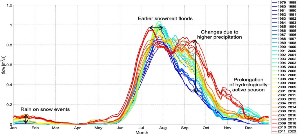
This study investigates the response of four High Arctic catchments with differing proportions of glacierization to changing climatic conditions. The study area located in SW Spitsbergen, has experienced a warming of 4.5 °C in the last 40 years along with a large increase in autumn rainfall. The changes in flow regime were determined based on available hydro-meteorological data and simulations of a semi-distributed rainfall-runoff model, which allowed recon-struction of streamflow in the period 1979–2020 and trend analyses for each calendar day. Similar trends of change were detected in all studied catchments. These include earlier onset of snowmelt driven floods (by two weeks over the period of analysis), large increases in autumn flows, prolongation of the hydrologically active season (starts earlier and lasts longer), decrease in flows in the latter half of June and the early part of August (except for the Breelva catch-ment). As a result of increases in autumn precipitation, the flood regime in these catchments has changed from snowmelt-dominated to the bi-modal with peaks in both July/August and September. The results also indicate differences in the magnitude of hydrological response depending on the percentage of glacial coverage in the catchments. The larger the glacierized area is, the larger the changes in the flow regime.
The hydrological regime of SW Spitsbergen catchments has undergone dramatic changes over the last four decades. Such a shift in hydro-climatic conditions is larger than that observed in lower latitudes and has significant environmental implications.

Link to the article: https://www.sciencedirect.com/science/article/abs/pii/S0048969722000134?via%3Dihub

A Digital Twin for GEOphysical extremes – DT-GEO

This is the title of a new project for which the IG PAS received funding from Horizon Europe. The project will last 36 months. The project coordinator from IG PAS is Prof. Beata Orlecka-Sikora.

With present computational capabilities and data volumes entering the Exascale Era, digital twins of the Earth system will be able to mimic the different system components (atmosphere, ocean, land, lithosphere) with unrivaled precision, providing analyses, forecasts, and what if scenarios for natural hazards and resources from their genesis phases and across their temporal and spatial scales.

DT-GEO aims at developing a prototype for a digital twin on geophysical extremes including earthquakes, volcanoes, tsunamis, and anthropogenic-induced extreme events. The project harnesses world-class computational and data Research Infrastructures (RIs), operational monitoring networks, and leading-edge research and academia partnerships in various fields of geophysics.

The project will merge and assemble latest developments from other European projects and Centers of Excellence to deploy 12 Digital Twin Components (DTCs), intended as self-contained containerized entities embedding flagship simulation codes, Artificial Intelligence layers, large volumes of (real-time) data streams from and into data-lakes, data assimilation methodologies, and overarching workflows for deployment and execution of single or coupled DTCs in centralized HPC and virtual cloud computing RIs. Each DTC addresses specific scientific questions and circumvents technical challenges related to hazard assessment, early warning forecast, urgent computing, or resource prospection. DTCs will be verified at 13 Site Demonstrators (SD) and their outcomes will contain rich metadata to enable (semi-)automatic discovery, contextualisation, and orchestration of software (services) and data assets, enabling its integration to the European Open Science Cloud (EOSC). The proposal aims at being a first step of a long-term community effort towards a twin on Geophysical Extremes integrated in the Destination Earth (DestinE) initiative.

Geosphere INfrastructures for QUestions into Integrated Research – Geo-INQUIRE

This is the title of a new project for which the IG PAS received funding from Horizon Europe. The project will last 48 months. The project coordinator from IG PAS is Prof. Mariusz Majdański.

Geo-INQUIRE will provide and enhance access to selected key data, products, and services, enabling the dynamic processes within the geosphere to be monitored and modelled at new levels of spatial and temporal detail and precision.

Geo-INQUIRE aims to overcome cross-domain barriers, especially the land-sea-atmosphere environments, and will exploit innovative data management techniques, modelling and simulations methods, developments in AI and big data, and extend existing data infrastructures to disseminate these resources to the wider scientific community, including the EOSC landscape.

Geo-INQUIRE benefits from a unique partnership of 52 partners consisting of major national research institutes, universities, national geological surveys, and European consortia. Geo- INQUIRE will enhance and make interoperable the activities of the involved partners and conduct dedicated training programs for their optimal use. A portfolio of 150 Virtual Access (VA) and Transnational Access (TA, both virtual and on-site) installations will be offered to the scientific community. While many such resources are already available at a high level of maturity, Geo-INQUIRE will ensure that they not only reach the highest level of scientific excellence through targeted actions on availability, quality, and spatial and temporal resolution, but also that they follow FAIR principles, adopt proper standards and open licenses, and aim at crossdisciplinary interoperability. Furthermore, the integration of different data, including new observables, products, and services will be optimized through TA activities via 7 test beds, which will also host workshops and summer schools dealing with the available resources.

Ultimately, Geo-INQUIRE, with its enhanced data, product, and service portfolio, will enable the next generation of scientists to carry out leading-edge research addressing societal challenges from a multidisciplinary perspective, making intelligent use of these resources.

“Seasonal trends and relation to water level of reservoir-triggered seismicity in Song Tranh 2 reservoir, Vietnam”

In a recent paper entitled “Seasonal trends and relation to water level of reservoir-triggered seismicity in Song Tranh 2 reservoir, Vietnam” published in Tectonophysics, we addressed seismicity induced by the exploitation of artificial water reservoirs. Changes in water levels in such reservoirs can cause strong and sometimes tragic earthquakes. Song Tranh 2 is a reservoir in central Vietnam with a maximum water level of 35 meters. The capacity of the reservoir is 740 million cubic meters, and the water level varies from 140 to 175 meters. Seismic activity in the area of the reservoir began in 2011, shortly after it was filled. Previously, this part of Vietnam was considered nearly aseismic. In our work, we focused on the impact of a gap in reservoir filling during maintenance operations and the effect of seasonal water level changes after refilling on seismicity and the associated hazard.

We found that the one-year pause in reservoir filling is characterized by nearly twice as much seismic activity and a significantly higher seismic hazard determined during this period for magnitude 3.5 and above compared to the time before the reservoir was emptied and after it was refilled. We have shown a seasonality of seismic activity in the latter period (2013-2016), which is related to water changes during the dry season, when water is released from the reservoir after reaching maximum filling, and the wet season, when water is collected during the period of increased rainfall. The greatest increase in activity is observed with a two to three month delay relative to the onset of water filling and release during the annual cycle of reservoir water collection and release. Related to this is also a significant difference in the seismic hazard. In the dry season, a tremor of magnitude 3.5 or stronger is almost three times more likely to occur than in the rainy season. Based on these results and by analyzing the delay with which an increase in activity occurs, we inferred that the main factor influencing seismicity triggering is the change in rock pore pressure associated with changes in water levels during the year.

This work was produced as part of a project number 2017/27/B/ST10/01267 funded by the NCN in the OPUS grant, the data used in the paper is available through the EPISODES platform (https://tcs.ah-epos.eu) as part of the Song Tranh episode.

Link to the article (open access): https://www.sciencedirect.com/science/article/pii/S0040195121004030

HR Excellence in Research

In November 2021, a series of information meetings with individual research departments took place to increase the awareness of participants in the field of the HRS4R procedure and the Logo HR award granted to the Institute. The meetings were conducted by three representatives of the HR Logo Working Group: MSc Roksana Chmielowska, MSc Izabela Nowaczyńska and dr. Piotr Klejment.

To understand the needs of researchers and doctoral students and to diagnose gaps within the 40 principles of the European Charter for Researchers and the Code of Conduct for the Recruitment of Researchers, on November 10-21, a survey was carried out at the IG PAS on the relevance and degree of implementation of the principles of the Charter and the Code at the IG PAS.

You can download the survey results here:

A broader analysis of the survey will be available in the updated IG PAS HR strategy in January 2022.

More information about the HRS4R procedure and the implementation of the HR Logo at IG PAS is available in the new tab: HR Excellence in Research on the Institute’s website.

What is Logo HR?

HR Excellence in Research is part of the Human Resources Strategy for Researchers (HRS4R) strategy, which aims to increase the attractiveness of working conditions, and thus the number of research workers in the European Union.

The Institute was awarded the HR Excellence in Research logo by the European Commission in June 2016, after meeting a number of formal requirements and submitting relevant documents.

The HR logo is awarded to supporting institutions and in practice applying the principles contained in the “European Charter for Researchers” and the “Code of Conduct for the Recruitment of Researchers”. These documents were issued in 2005 as a recommendation of the European Commission addressed to scientists, employers and research funders operating in the public and private sectors.

• The European Charter for Researchers describes the rights and obligations of researchers, their employing institutions and research funding organizations.

• The Code of Conduct for the Recruitment of Researchers describes the rules for the recruitment of researchers that employers should follow to ensure equal treatment of researchers in Europe.

More about the HRS4R strategy on the Euraxess website: https://euraxess.ec.europa.eu/jobs/hrs4r

Thematic Core Services – Anthropogenic Hazards (TCS-AH) June 2021 Online Workshop & Training Summary

On June 16th a TCS-AH half day online workshop took place entitled TCS AH Research Infrastructures and Use Cases for and by the Induced Seismicity Community’. The event involved ~40 participants and began with Ania Lesnodorska from the hosting institution (IG PAS) delivering an overview of the TCS including it’s history, formation, technical facilities and consortium partners. This was followed by a presentation from Mieszko Makuch (ACC Cyfronet AGH) on the status of the IS-EPOS Platform and recent developments including the major new functionalities of the AH research infrastructure.

 EPOS’s ICS-C (Integrated Core Service – Central) and the integration of the AH Infrastructure (the IS-EPOS Platform) was then presented by Kuvvet Atakan (UiB).

The second half of the workshop focused on TCS AH research infrastructure use case examples and covered:

  • Public engagement potential through visualisations of Episode Data (Ian Stimpson, KU) 
  • Seismic moment evolution during hydraulic stimulations (Grzegorz Kwiatek, GFZ)
  • Completeness magnitude estimation of an induced seismic catalog (Kamel Drif, UNISTRA/EOST)
  • The use of data and software tools for induced seismicity research (Alexander Garcia, INGV).

Sessions were followed by Q&A and open discussion and highlighted the definition, novelty and importance of datasets packaged as ‘Episodes’ (i.e. a set of time-correlated data and data products grouped together to facilitate the correlation and analysis of anthropogenically induced or triggered processes and hazards).  

Overall, the workshop struck a great balance in providing attendees with a well structured and diverse mix of sessions and content to learn about the TCS and EPOS in general, whilst also demonstrating how the TCS-AH could be utilised for induced seismicity research AND also for capturing greater public attention through the assimilation of Episode data into art!

A screenshot of a video game

Description automatically generated

Following the workshop, a 2 hour online training session on the IS-EPOS platform took place on the 17th June with 18 participants. Michal Lelonek of IG PAS presented the platform by showcasing Episode data from across four continents and four different industries. The first presented episode was Asfordby, related to the no longer operating coal mine in Great Britain. The next episode, Australian Cooper Basin, related to a geothermal hydraulic stimulation was used to show data visualization methods. The relationship between injection rate and seismic activity was also presented.  Then, the continent was changed to North America and, based on the episode of Oklahoma associated with conventional and unconventional hydrocarbon extraction, where the “Catalog Filter” application was discussed. The last episode presented was the Vietnamese Song Tranh, related to a reservoir impoundment. The episode was used to present slightly more advanced applications: spectral analysis and FOCI – an application for resolving seismic moment tensors. Workshop participants could also observe how the P and S waves are picked, as well as methods to load their own data sets into the workspace.

The training event provided a great introductory step towards more advanced training series to be happening in the future!

A screenshot of a computer

Description automatically generated with medium confidence

Awards for outstanding scientific and administrative employees

The annual reports on the scientific work of the Institute took place on March 23-24 and March 30-31. A nice part during the last reporting session was the “virtual” presentation of the awards of the Director of the Institute of Geophysics PAS, awarded to outstanding scientific and administrative employees. Among the awarded were:

  • Dr. Oskar Głowacki, who received I award of the Director of the Institute of Geophysics PAS
  • Dr. Bartłomiej Luks, who received II award of the Director of the Institute of Geophysics PAS
  • Dr. Tomasz Wawrzyniak, who received II award of the Director of the Institute of Geophysics PAS
  • Dr. eng. Agnieszka Czerwińska, who received award of distinction
  • Assoc. Prof. Michael Nones, who received award of distinction
  • Department employees of “PSP HORNSUND”: Włodzimierz Sielski, Grażyna Dziurla, Katarzyna Matysiak, Marcin Ruszczak
  • eng. Rafał Jasiński
  • team award: Prof. Paweł Rowiński, Assoc. Prof. Monika Kalinowska, Assoc. Prof. Michael Nones, dr. Anna Łoboda, dr. Łukasz Przyborowski
  • team award: Prof. Stanisław Lasocki, M.Sc. Anna Leśnodorska, M.Sc. Karolina Chodzińska, M.Sc. eng. Izabela Dobrzycka, M.Sc. Marcin Zimny, M.Sc. Witold Olszewski, M.Sc. Alicja Caputa, M.Sc. Beata Plesiewicz, M.Sc. Dominika Wenc, Kaj Michałowski, M.Sc. eng. Michał Lelonek.

The absence of the Polish Academy of Sciences in the National Reconstruction Plan

Comment by prof. Paweł Rowiński, Vice President of the Polish Academy of Sciences

“Recently, it is not a bed of roses at the Polish Academy of Sciences. The attempt to marginalize the Academy through this sick idea of ​​the National Copernican Program is not the only strange event. In the National Reconstruction Plan, the Academy was forgotten as the only entity in the science and higher education sector. Quite significant, because according to various rankings of the highest ranked Polish scientific and research institutions, the Polish Academy of Sciences takes the first place (e.g. Scimago Institutions Ranking or Nature Index). In recent years, the institutes of the Polish Academy of Sciences have strengthened cooperation with institutions from the economy, business and administration sectors, and significantly improved innovation indicators. Yesterday [09/04/2021] it was heard at the session of the parliamentary standing subcommittee for science and higher education. The media has already noticed this, I encourage you to read the report in DGP https://serwisy.gazetaprawna.pl/…/8137269,wojciech…. I wonder if the promise made there will be kept. Anyway, the entire structure of this Reconstruction Plan is interesting. The Spaniards planned 34 percent for science in their program, and we – as our colleagues from KRASP noticed – as much as usual, i.e. approx. 1 percent. We rebuild differently … “

Comment by IG PAS Management

The IG PAS Management and the Chairman of the IG PAS Scientific Council fully share the criticisms of the concept of the National Copernican Program, in particular the plan to establish the International Copernican Academy. It can be assumed that the goal of the Minister of MEiN is to establish an opinion-forming center alternative to the Polish Academy of Sciences. In our opinion, the appointment of such a body, additionally subordinated to the political authority, will not allow achieving the above-mentioned goals in the proposed provisions of the draft Act on NPK, including the improvement of the level of science in Poland, the increase of international recognition of Polish scientists, and the faster development of young scientific staff.

Taking into account all aspects and possible political background of the whole matter, we express our support for further actions of the management of the Polish Academy of Sciences to calm the situation in the scientific community and to rationalize, in cooperation with the political authorities, work on the amendment to the Act on the Polish Academy of Sciences.

The first scientific and technical conference devoted to the EPOS-European Plate Observation System (EPOS-PL +) project

“Just over a year ago, the conference opening the EPOS-PL+ project took place, and today we are meeting remotely (on-line) to summarize the first year of working together in the project”, said Prof. Stanisław Prusek, Director of the Central Mining Institute (GIG) – an institution that is the leader of the EPOS-PL+ project – while opening this year’s project conference.

The EPOS PL+ conference was held on March 25, 2021, online. It was divided into four sessions on: IS-EPOS Platform, Centre for Induced Seismicity Research Infrastructure (CIBIS); The Geophysical Safety System for Mining Protection Pillars for long-life corridor excavation in mines; Center for Research Infrastructure of Geomagnetic and Magnetotelluric Observations (CIBOGM) and Center for Research Infrastructure of Analytical Laboratories (CIBAL); ground level deformation monitoring systems, which presented issues related to the integration of research infrastructure: GNSS Data Center (CIBDG), Satellite Data Center (CIBDS), Gravimetric Observation Center (CIBOG) and Global Geodetic Observation System in Poland (GGOS-PL ++).

During the conference, their papers were delivered, among many others by :

  • Prof. Beata Orlecka-Sikora (IG PAS), who introduced the history and concept of the EPOS project in Europe and Poland, i.e. the creation of a virtual platform / forum aimed at enabling cooperation of scientists in the field of environmental hazards, in particular seismic hazards, and integrating research infrastructure in the field of Earth Sciences.
  • MSc. Michał Lelonek (IG PAS), took the conference participants on a virtual “tour” of the IS-EPOS Platform (https://tcs.ah-epos.eu/) – a platform integrating data, specialized software and library materials regarding geophysical hazards associated with exploitation of georesources.
  • Assoc. Prof. Łukasz Rudziński (IG PAS), gave a lecture on the observation of tremors in mines with the use of broadband seismometers – CIBIS.
  • Dr. Szymon Oryński, Dr. Katarzyna Dudzisz (IG PAS) – lecture entitled Monitoring of the migration of post-industrial pollutants using the conductometric method and electrofusion tomography.
  • Dr. Sylwia Dytłow, Dr. Katarzyna Dudzisz, Dr. Tomasz Werner (IF PAS) – presented the use of a field laboratory for environmental research to analyze the level of pollution (particulate matter, black carbon) and magnetic susceptibility in urban environment and in post-industrial areas.

The conference was closed by Assoc. Prof. Adam Lurka, EPOS-PL+ project manager, who thanked for the interesting presentations and wished further success in the implementation of the tasks planned in the project.

Great success of Thematic Core Service Anthropogenic Hazards Consortium (TCS AH)

On March 11, 2021, a three-year collaboration agreement was signed between EPOS ERIC (European Plate Observing System, European Research Infrastructure Consortium) and the TCS AH (Thematic Core Service Anthropogenic Hazards) Consortium. On behalf of TCS AH, the Agreement was signed by Professor Beata Orlecka-Sikora, Director of the Institute of Geophysics, Polish Academy of Sciences, which is the leading institution of the Consortium. This fact, preceded by many months of Consortium efforts, is the undeniable success of TCS AH, which permanently connects the TCS AH Consortium with EPOS ERIC, giving a broader formal basis and financial support for activities under: Governance & Coordination, Integrated Core Services-Central interactions and Outreach & Dissemination for years 2021-2023.

TCS AH is the first and so far the only TCS Consortium to have signed a multi-year collaboration agreement with EPOS ERIC.

TCS AH is a Consortium of 12 European research and scientific institutions. It was established as part of EPOS ERIC (European Plate Observing System, European Research Infrastructure Consortium), inaugurated its activities on November 18, 2019. The Consortium is a response to the problems related to the exploitation of geosources in the European Union. Its creation was initiated by the scientific, industrial and other units actively involved or interested in diagnosing and counteracting hazards resulting from exploitation activities.

In recent years, the Institute of Geophysics, Polish Academy of Sciences has led the integration of European infrastructures for the study of anthropogenic hazards and preparations for the establishment of the TCS AH Consortium. In recognition of this role, the TCS AH Consortium Board entrusted the role of the leading institution in the Consortium – Host Institution – to the Institute of Geophysics. This is one of the few examples of managing a fragment of ESFRI infrastructures: European Strategy Forum on Research Infrastructures by a Polish research institution. The director of TCS AH, since 2019, is Professor Stanisław Lasocki.